The Hyderabad Metro is one of India’s most modern and efficient metro rail systems. Launched to reduce traffic congestion and improve connectivity, it has quickly become the lifeline of the city. Whether you are a daily commuter, a student, or a tourist, understanding the Hyderabad Metro Map is essential for smooth travel.
In this blog, we’ll explore everything about the Hyd Metro Map, including routes, stations, timings, ticket prices, smart cards, and travel tips.
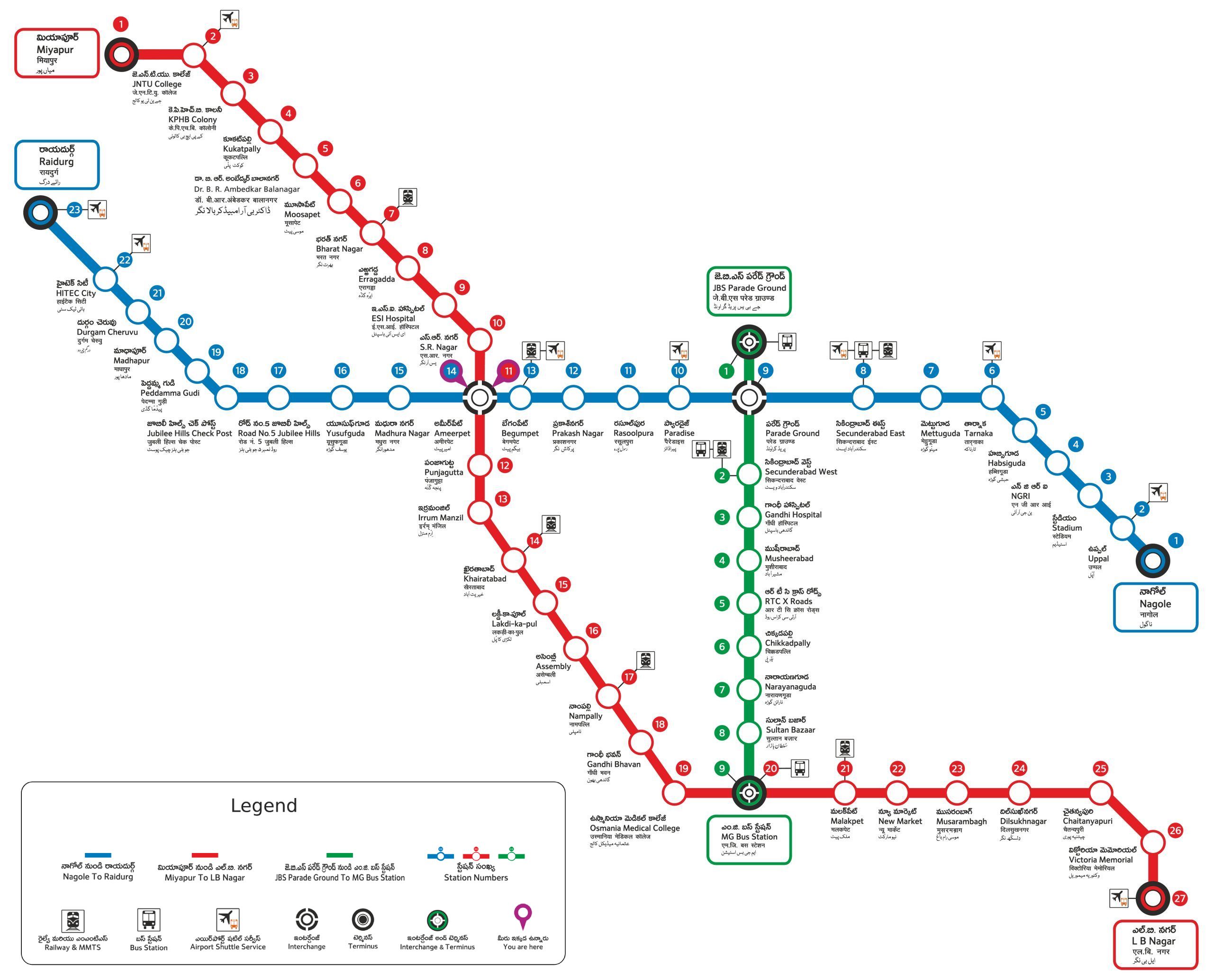
What Is Hyderabad Metro?
The Hyderabad Metro Rail (HMR) is a rapid transit system serving Hyderabad, the capital of Telangana. It is developed under a Public-Private Partnership (PPP) model with L&T Metro Rail (Hyderabad) Limited. The metro network is designed to cover the busiest parts of the city and connect key commercial, educational, and residential areas.
Key Features:
- Total length: ~69.2 km
- Total stations: 57
- Operational lines: 3 (Red, Blue, Green)
- Operator: L&T Metro Rail (Hyderabad) Limited
- Daily ridership: Over 4 lakh passengers (and growing)
Hyd Metro Map Overview
The Hyderabad Metro Map is divided into three main corridors — Red Line, Blue Line, and Green Line — that cover the majority of the city. Let’s break down each one:

🔴 Red Line: Miyapur to LB Nagar
- Route Length: 29 km
- Total Stations: 27
- Starting Point: Miyapur
- Ending Point: LB Nagar
- Major Stops: JNTU College, Kukatpally, Bharat Nagar, Ameerpet, Dilsukhnagar, Koti, LB Nagar
This is the longest and busiest line, connecting the northwestern and southeastern parts of Hyderabad. It passes through key residential and business hubs.
🔵 Blue Line: Nagole to Raidurg
- Route Length: 27 km
- Total Stations: 23
- Starting Point: Nagole
- Ending Point: Raidurg
- Major Stops: Uppal, Tarnaka, Parade Ground, Ameerpet (interchange), Madhapur, Hitech City, Raidurg
This line is very popular among IT professionals, as it covers the Hitech City and Gachibowli areas — the heart of Hyderabad’s IT corridor.
Green Line: JBS Parade Ground to MGBS
- Route Length: 11 km
- Total Stations: 9
- Starting Point: JBS Parade Ground
- Ending Point: MGBS (Mahatma Gandhi Bus Station)
- Major Stops: Secunderabad West, Chikkadpally, Narayanguda, Sultan Bazaar, MGBS
The Green Line provides an essential connection between the Secunderabad and Hyderabad parts of the city.
Interchange Stations
The Hyderabad Metro has two key interchange stations where passengers can change between lines:
- Ameerpet Station – Interchange between Red Line and Blue Line
- MGBS Station – Interchange between Blue Line and Green Line
These interchanges make it easy to travel across the entire metro network without exiting the system.
Hyderabad Metro Timings
- First Train: Around 6:30 AM
- Last Train: Around 10:30 PM
- Frequency: Every 3–7 minutes during peak hours and every 8–10 minutes during non-peak hours
👉 Tip: Check the Hyderabad Metro official app or website for live train timings and service updates.
Hyderabad Metro Ticket Prices & Smart Cards
Token Tickets:
- Available at every station through ticket counters and vending machines.
- Prices range from ₹10 to ₹60, depending on distance.
Smart Card:
For frequent travelers, the Metro Smart Card is a convenient option.
- Rechargeable online or at stations.
- Offers 10% discount on every journey.
- Can be purchased for around ₹100 (₹50 refundable deposit).
Major Metro Stations and Nearby Attractions
| Metro Station | Nearby Attractions |
|---|---|
| Ameerpet | Central Business Hub, Shopping Centers |
| Raidurg | Hitech City, Inorbit Mall, IT Offices |
| Miyapur | Residential Area, Local Markets |
| MGBS | Bus Station, Old City, Charminar (via road) |
| Secunderabad East | Railway Station, Clock Tower |
| Dilsukhnagar | Commercial Area, Theatres, Restaurants |
Hyderabad Metro App and Digital Facilities
The T-SMART (Telangana State Metro App) provides:
- Real-time train updates
- Route planning
- Fare calculator
- Smart card recharge
- Lost & Found service
You can also use UPI or Paytm QR for ticket purchase at the stations.
Future Expansion Plans (2025 and Beyond)
The Hyderabad Metro is set to expand further! The Phase 2 project will add new lines and extend existing routes.
Planned Extensions:
- Raidurg to Airport Line (31 km) – Connecting the IT corridor to Rajiv Gandhi International Airport (RGIA).
- BHEL to Lakdikapul – Improving connectivity to central Hyderabad.
- New Corridors under planning: LB Nagar–Hayathnagar and Nagole–LB Nagar.
Once completed, the total network will exceed 120 km, making it one of India’s largest metro systems.
💡 Travel Tips for Hyderabad Metro Users
- Avoid peak hours (8–10 AM & 6–8 PM) if you want a peaceful ride.
- Use Smart Cards to skip long queues.
- Follow security checks – all bags are scanned at entry.
- Keep your tokens safe – needed to exit the station.
- Download the metro app for route and timing info.
🏙️ Why Hyderabad Metro Is a Game-Changer
The metro has transformed Hyderabad’s public transport system by:
- Reducing traffic jams
- Cutting travel time by up to 40%
- Promoting eco-friendly travel
- Improving access to workplaces, schools, and tourist sites
Hyderabad Metro is not just a transportation system — it’s a symbol of smart urban development and a step toward a sustainable future.
Conclusion
Understanding the Hyderabad Metro Map helps you plan your journeys effectively across the city. With three main corridors, modern stations, affordable fares, and ongoing expansions, the metro has become the backbone of Hyderabad’s transportation.
So, next time you travel — skip the traffic, hop on the metro, and explore the City of Pearls in comfort!