The Mumbai Metro is rapidly transforming how Mumbaikars travel. Designed to decongest the city’s overburdened roads and suburban railways, the metro system now includes operational lines, interchanges, and many new corridors under construction.
If you’re looking for the latest Mumbai Metro Map, route planning tips, or fare info — Metromap.in has it all in one place.
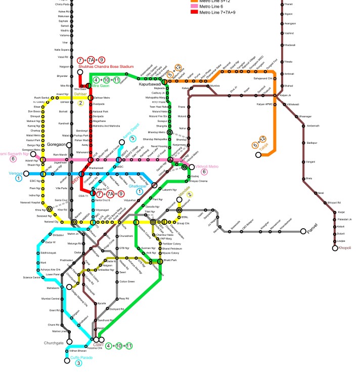
Mumbai Metro’s map is a color-coded diagram that visually represents all operational and planned lines, interchanges, and terminal stations. The Mumbai Metro Map is more than a travel tool — it’s your key to smart city commuting. With fast-expanding routes and better last-mile options, Metro is reshaping Mumbai’s future.
Interchange Stations:
- DN Nagar – Line 1 & Line 2A
- Gundavali (Andheri East) – Line 1 & Line 7
- Dahisar East – Line 2A & Line 7
Mumbai Metro Map
| Line | Name | Route |
|---|---|---|
| Line 1 | Blue Line | Versova – Andheri – Ghatkopar |
| Line 2A | Yellow Line (Western) | Dahisar East – DN Nagar |
| Line 2B | Yellow Line (Eastern) | DN Nagar – Mandale (Under Progress) |
| Line 3 | Aqua Line (Coming soon) | Colaba – Bandra – SEEPZ (Underground) |
| Line 4 | Green Line | Wadala – Kasarvadavali (Under Construction) |
| Line 7 | Red Line | Dahisar East – Gundavali (Andheri E) |
Upcoming Lines
Mumbai Metro will ultimately have over 14 lines stretching across 300+ km, connecting major suburbs and business hubs like:
- Colaba, Bandra, BKC, Thane, Navi Mumbai, Mira-Bhayandar, and Vasai-Virar.
Mumbai Metro Fare & Smart Card
- Base fare starts at ₹10 and goes up to ₹40+ depending on distance.
- Use a Mumbai Metro Smart Card for cashless travel and quicker entry.
- Soon, NCMC (National Common Mobility Card) will be accepted across all lines.