Delhi Metro is the lifeline of the capital city, connecting every corner of Delhi NCR with fast, affordable, and comfortable transport. Millions of passengers travel daily using Delhi Metro, and to make travel easier, having the Delhi Metro Map in Full HD is very important. This blog will provide you with the latest Delhi Metro Map (2025 update) in High Definition (HD) so that you can zoom in and see every detail clearly.
What is Delhi Metro Map?
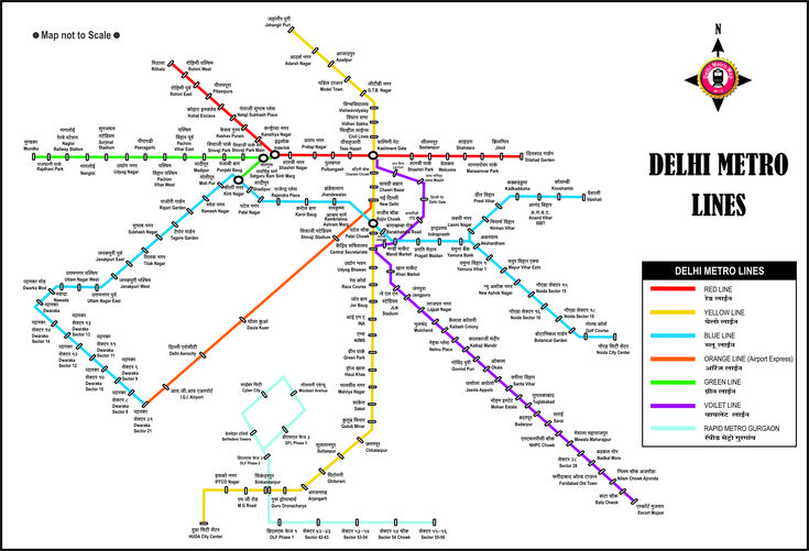
Delhi Metro Map is a graphical representation of all metro lines, stations, and routes that operate under the Delhi Metro Rail Corporation (DMRC). It helps passengers plan their journey, check interchanges, and calculate travel time.
Overview Table of Delhi Metro (2025)
| Feature | Details |
|---|---|
| Total Metro Lines | 10 (including Airport Express) |
| Total Stations | 288+ operational stations |
| Coverage Area | Delhi, Noida, Ghaziabad, Gurgaon, Faridabad, Bahadurgarh |
| Daily Ridership | More than 65 lakh passengers |
| Map Format | Full HD (High Definition) |
Why You Need Full HD Delhi Metro Map?
- Clear Details – All stations and routes are visible even when zoomed.
- Easy Travel Planning – Check shortest routes and interchanges.
- Time Saving – Helps avoid confusion during rush hours.
- Mobile Friendly – Can be saved on phone for quick use.
Latest Delhi Metro Map (2025 Full HD)
The updated Delhi Metro Map includes all the operational lines such as Red, Yellow, Blue, Violet, Magenta, Pink, Green, Grey, and the Airport Express Line.
Delhi Metro Lines with Colors
- Red Line – Rithala to Shaheed Sthal (Ghaziabad)
- Yellow Line – Samaypur Badli to HUDA City Centre (Gurgaon)
- Blue Line – Dwarka Sector 21 to Noida Electronic City / Vaishali
- Green Line – Inderlok/Kirti Nagar to Brigadier Hoshiyar Singh
- Violet Line – Kashmere Gate to Raja Nahar Singh (Faridabad)
- Magenta Line – Janakpuri West to Botanical Garden
- Pink Line – Majlis Park to Shiv Vihar
- Grey Line – Dwarka to Najafgarh / Dhansa Bus Stand
- Airport Express Line – New Delhi Railway Station to Dwarka Sector 21
Benefits of Using Delhi Metro Map in HD
- Helps tourists and newcomers understand Delhi Metro easily.
- Provides accurate interchange points.
- Saves internet data when used offline.
- Useful for office-goers, students, and daily commuters.
How to Get Delhi Metro Map in Full HD?
- Visit official DMRC website.
- Download the PDF or JPG version of the map.
- Save it on your mobile phone for offline access.
- You can also take a printout for regular travel reference.
Conclusion
The Delhi Metro Map Full HD (2025) is the best way to travel smartly across the city. Whether you are a daily commuter, student, or tourist, keeping the latest updated map will save time and make your journey smooth