If you travel by metro, then you will definitely need a metro map. Metro is running in all the cities of India on this website. You can download city wise metro map PDF in HD quality. What is the benefit of metro map, how to download metro map, all the information is given at the bottom of this article. So I will definitely advise you that if you are also going to travel by Delhi Metro, Hydrabad Metro, Chennai Metro, Bengaluru Metro, Mumbai Metro, Patna Metro, etc., then definitely check the metro map from this website once.
Below you have given the metro map PDF download link of all the cities, you can download it from there
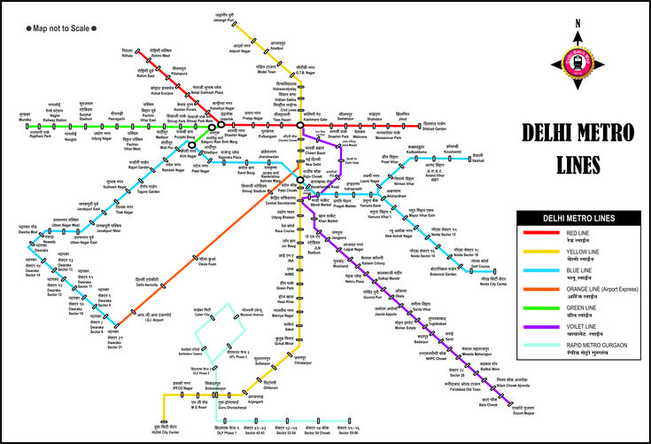
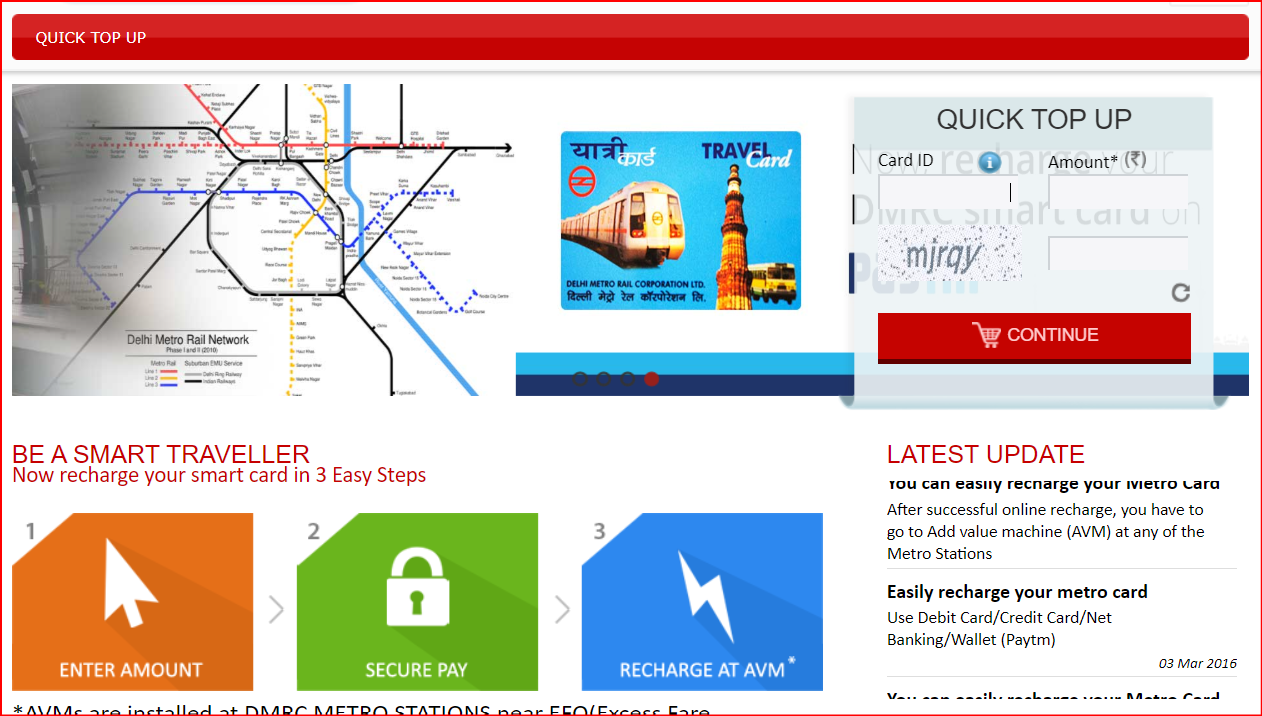
Delhi Metro full Hd Map
The Delhi Metro Map is a graphical representation of the Delhi Metro Rail Network, showing all the metro lines, stations, and interchanges across Delhi and the National Capital Region (NCR). Here’s a general overview:
Key Interchange Stations
- Kashmere Gate – Red, Yellow, Violet
- Rajiv Chowk – Blue, Yellow
- Central Secretariat – Yellow, Violet
- Mandi House – Blue, Violet
- Janakpuri West – Blue, Magenta
- Hauz Khas – Yellow, Magenta
- Botanical Garden – Blue, Magenta
- Anand Vihar – Blue, Pink
Download Delhi Metro Map PDF File
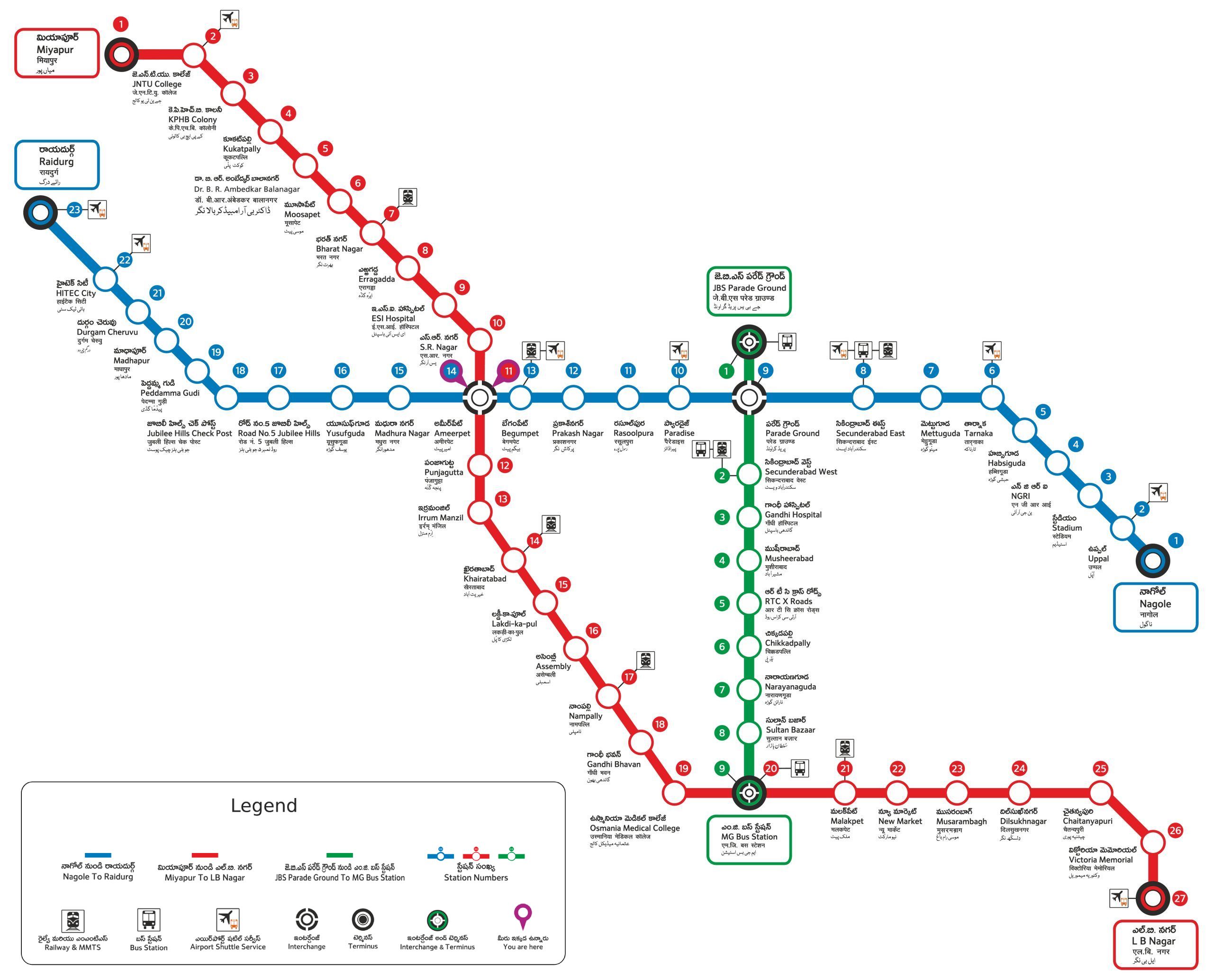
Hydrabad Metro Map
The Hyderabad Metro is a rapid transit system serving the city of Hyderabad, Telangana. It is the third longest operational metro network in India, after the Delhi Metro and Bengaluru’s Namma Metro.
Key Features of Hydrabad Metro
- Operational Lines: The metro has three fully operational lines—Red Line (Miyapur to LB Nagar), Green Line (JBS Parade Ground to Mahatma Gandhi Bus Station), and Blue Line (Nagole to Raidurg).
- Daily Ridership: Over 536,000 passengers use the metro daily.
- Speed & Efficiency: Trains operate at speeds of up to 80 km/h, reducing travel time significantly.
- Expansion Plans: The metro network is expected to grow further, with new corridors under construction.
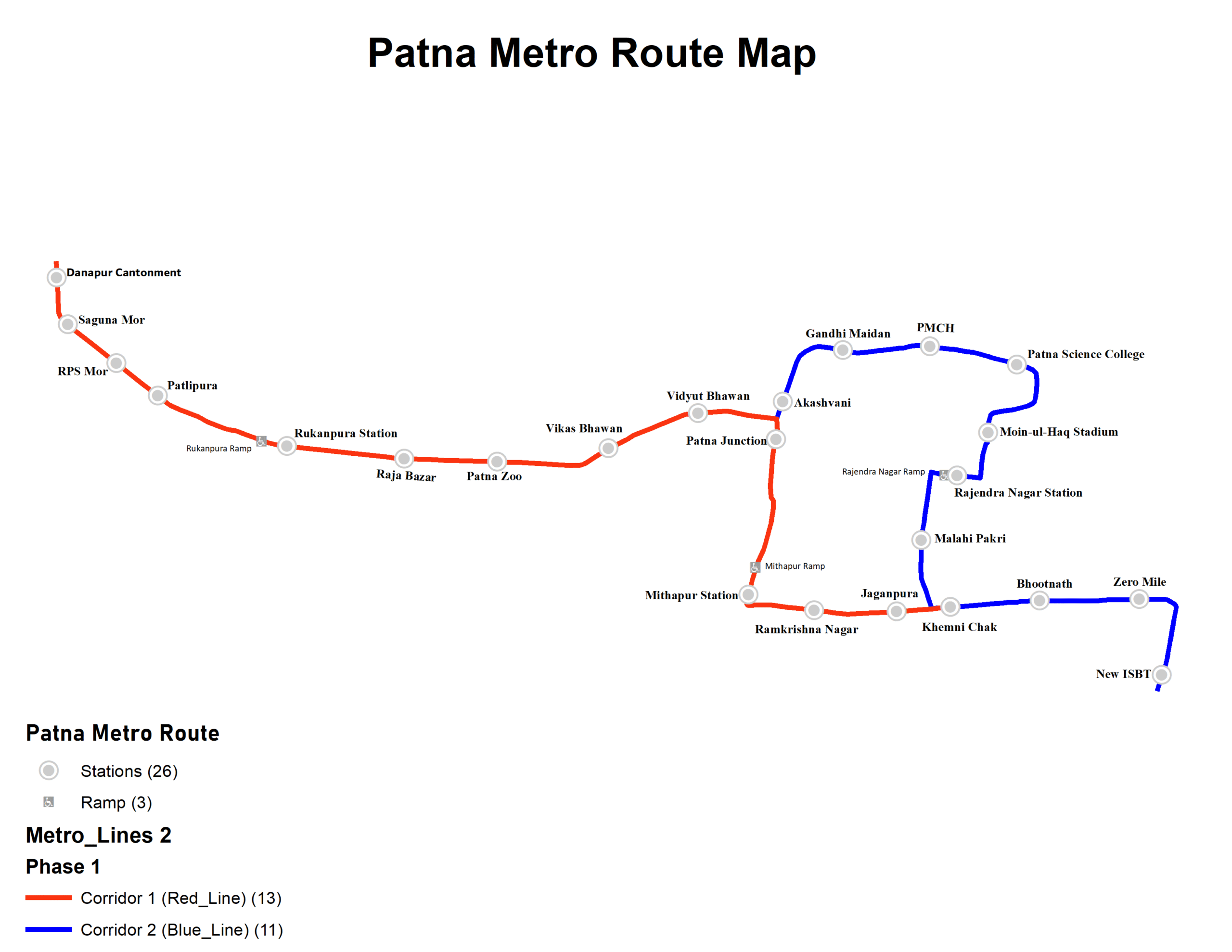
Hydrabad Metro Map Pdf
Recent Developments
- Service Disruption: On May 5, 2025, metro services were briefly disrupted due to heavy rains and winds affecting the overhead power supply between Khairatabad and Irrumanzil. Operations resumed with single-line working while repairs were underway.
- New Passenger Website: Hyderabad Metro Rail recently launched a new passenger website to enhance user experience and provide real-time updates.
The Hyderabad Metro is transforming urban transportation, offering a faster, more comfortable, and eco-friendly alternative to traditional modes of travel. Have you had a chance to ride the metro yet?
Banlore Metro Map
The Bangalore Metro, officially known as Namma Metro, is a rapid transit system serving Bengaluru, Karnataka. It is the second-longest operational metro network in India, after the Delhi Metro.
| Line Color | Line Name | Route | Length | Status |
|---|---|---|---|---|
| 🟣 Purple Line | Baiyappanahalli ↔ Kengeri | 25.7 km | Operational | Connects East-West corridors |
| 🟢 Green Line | Nagasandra ↔ Silk Institute | 30.5 km | Operational | Connects North-South corridors |
| 🟡 Yellow Line | R.V. Road ↔ Bommasandra | 18.8 km | Expected to be operational by July 2025 | Interchange at Jayadeva Hospital with Pink Line |
| 🟠 Orange Line | Silk Board ↔ Kempegowda International Airport | 38 km | Under Construction | Connects city center to airport |
| 🟣 Pink Line | Kalena Agrahara ↔ Nagawara | 21.25 km | Under Construction | Interchange at MG Road with Purple Line |
| 🔵 Blue Line | Central Silk Board ↔ KR Puram | 17 km | Under Construction | Part of Phase 2A and 2B expansions |
| 🔴 Red Line | Gottigere ↔ Nagawara | 21.25 km | Proposed | Part of Phase 3 expansions |
Banglore Metro Map PDF Download
Key Features
- Operational Lines: The metro has two fully operational lines—Purple Line (Baiyappanahalli to Whitefield) and Green Line (Nagasandra to Silk Institute).
- Daily Ridership: Over 762,000 passengers on average.
- Speed & Efficiency: Trains operate at speeds of up to 80 km/h, reducing travel time significantly.
- Expansion Plans: Several new lines, including the Yellow, Pink, Blue, Orange, Grey, and Red Lines, are under construction.
Recent Developments
- Fare Hike: On February 9, 2025, Namma Metro increased fares, making it the costliest metro system in India. The fare hike resulted in a 100% increase on certain routes, later capped at 71% following public backlash.
- Ridership Record: On December 6, 2024, Namma Metro recorded its highest-ever ridership of 920,562 passengers.
- New Extensions: The Yellow Line is expected to open soon, improving connectivity across the city.
Namma Metro is transforming urban transportation, offering a faster, more comfortable, and eco-friendly alternative to traditional modes of travel. Have you had a chance to ride the metro yet?
Chennai metro Map
The Chennai Metro is a rapid transit system serving the city of Chennai, Tamil Nadu. It is operated by Chennai Metro Rail Limited (CMRL) and aims to provide a fast, efficient, and eco-friendly mode of transportation.
Chennai-Metro-Map-PdfDownload Chennai Metro Map
| Line Color | Line Name | Route | Length | Status | Key Interchanges / Notes |
|---|---|---|---|---|---|
| 🔵 Blue Line | Line 1 | Chennai Airport ↔ Wimco Nagar | 32.15 km | Operational | Interchange at Alandur with Green Line |
| 🟢 Green Line | Line 2 | Chennai Central ↔ St. Thomas Mount | 22 km | Operational | Interchange at Alandur with Blue Line |
| 🟣 Purple Line | Line 3 | Madhavaram Milk Colony ↔ Siruseri SIPCOT | 45.4 km | Under Construction | Part of Phase 2 expansion |
| 🟠 Orange Line | Line 4 | Light House ↔ Poonamallee Bypass | 26.1 km | Under Construction | Part of Phase 2 expansion |
| 🔴 Red Line | Line 5 | Madhavaram ↔ Sholinganallur | 44.6 km | Under Construction | Part of Phase 2 expansion |
Key Features
- Operational Lines: The metro currently has two operational lines—Blue Line (Airport to Washermanpet) and Green Line (Central to St. Thomas Mount).
- Daily Ridership: Over 345,000 passengers use the metro daily.
- Speed & Efficiency: Trains operate at speeds of up to 120 km/h, reducing travel time significantly.
- Expansion Plans: Three additional lines—Purple, Yellow, and Red Lines—are under construction to enhance connectivity.
Recent Developments
- Phase 2 Expansion: The metro network is expanding with 118.9 km of new routes, making it one of the largest metro systems in India.
- New Ticketing System: Chennai Metro Rail Limited recently introduced a QR-based ticketing system for seamless travel.
- Improved Connectivity: The metro is integrating with suburban rail and bus networks to provide better last-mile connectivity.
The Chennai Metro is transforming urban transportation, offering a faster, more comfortable, and eco-friendly alternative to traditional modes of travel. Have you had a chance to ride the metro yet?
FAQ- Metro Map
How do I read a metro map?
Metro maps use color-coded lines to represent different routes. Stations are marked along these lines, and transfer points indicate where passengers can switch lines.
Where can I find an updated metro map?
Most metro systems provide official maps on their websites or at metro stations. Some cities also have mobile apps with real-time updates.
How do I plan my journey using a metro map?
Identify your starting station and destination, then follow the color-coded route to see if you need to transfer at any interchange stations.
Are metro maps available in different languages?
Many metro systems offer maps in multiple languages, especially in cities with international travelers.
Do metro maps show fare details?
Some metro maps include fare zones, while others require passengers to check fare calculators on official websites.
How often are metro maps updated?
Metro maps are updated whenever new lines or stations are added to the network.