India’s metro network is expanding rapidly, connecting cities and easing the pressure on road transport. Among the upcoming projects, the Silver Line Metro has gained special attention. Whether you are a daily commuter, a student, or a traveler, knowing about the Silver Line Metro Map will help you plan your journey better.
In this blog, we will cover everything you need to know about the Silver Line Metro, including its route, stations, importance, ticketing system, and latest updates.
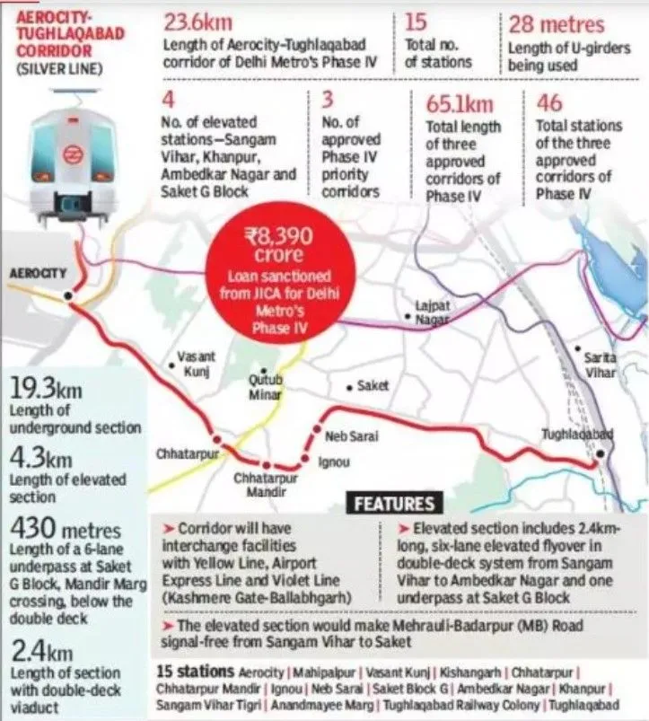
The colour of the Golden Line Delhi Metro was officially changed in January 2024. Earlier the colour was Silver and it was called Silver Line Delhi Metro. After that in November 2023 the colour code was changed to Gold colour. Later in January 2024 it was again changed to the Golden Line.
What is the Silver Line Metro?
The Silver Line Metro refers to a newly planned metro corridor designed to improve urban connectivity. In India, multiple cities are working on metro projects, and the Silver Line is one of the major additions to the network.
The Silver Line Metro Map shows the full route, interchanges, and key stations. It is designed to connect important residential, business, and travel hubs, reducing road traffic and saving time for passengers.
Silver Line Metro Route Overview
The Silver Line Metro will cover a significant stretch of urban and semi-urban areas. The route is carefully designed to ensure:
- Connectivity to residential colonies
- Access to major markets, hospitals, and offices
- Smooth travel to railway stations, airports, and bus terminals
On the Silver Line Metro Map, passengers can see all starting and ending points, along with interchange stations that link to other metro lines.
The following are the stations proposed to be built on the Golden Line of the Delhi Metro.
| S.No. | Delhi Metro Golden Line Stations | Station Layout |
| 1 | Delhi Aerocity | Underground |
| 2 | Mahipalpur | Underground |
| 3 | Vasant Kunj Sector-D | Underground |
| 4 | Kishangarh | Underground |
| 5 | Chhatarpur | Underground |
| 6 | Chhatarpur Mandir | Underground |
| 7 | IGNOU | Underground |
| 8 | Neb Sarai | Underground |
| 9 | Saket G-Block | Underground |
| 10 | Ambedkar Nagar | Elevated |
| 11 | Khanpur | Elevated |
| 12 | Sangam Vihar – Tigri | Elevated |
| 13 | Anandmayee Marg | Underground |
| 14 | Tughlakabad Railway Colony (Pul Prahladpur) | Underground |
| 15 | Tughlakabad Station | Underground |
Major Highlights of the Silver Line Metro
- Color Code – Silver: Easy to identify on metro maps.
- Route Length: Expected to be more than 20–30 km, depending on the city plan.
- Modern Coaches: Air-conditioned, energy-efficient trains.
- Eco-Friendly: Will run on electricity, reducing fuel usage.
- Time-Saving: Travel time will reduce by up to 50% compared to road traffic.
Key Stations on Silver Line Metro Map
While the final list of stations may vary depending on the project city, some key stations expected are:
- Residential hubs
- IT and business parks
- Major railway stations
- Airport connectivity points
- Interchange stations with existing metro lines
This makes the Silver Line a crucial part of daily commuting in the region.
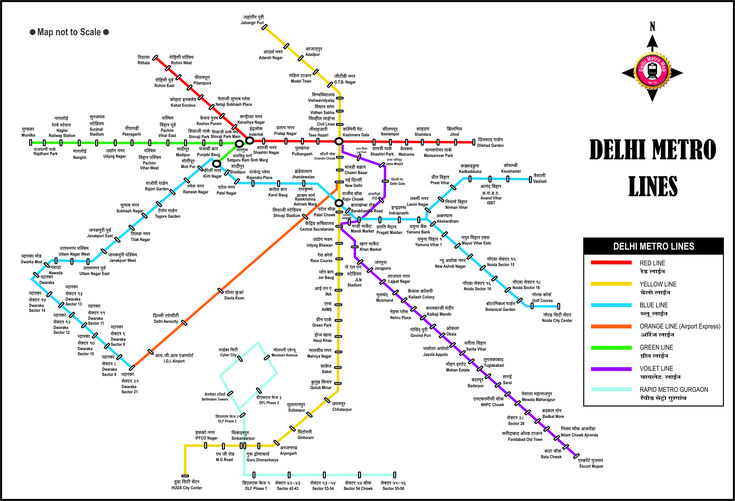
Interchange Facilities
Like other metro networks, the Silver Line Metro Map includes interchange stations. This allows passengers to switch between different lines without exiting the system.
For example:
- Connection with Red Line (Oldest metro routes)
- Connection with Blue Line (Long-distance metro travel)
- Connection with Airport Express Lines
These interchanges make the Silver Line an integrated transport solution.
Silver Line Metro Ticketing System
- Smart Card: Passengers can use rechargeable smart cards for daily travel.
- Tokens: Available for one-time journeys.
- Digital Payment: UPI, debit/credit card, and online recharge options.
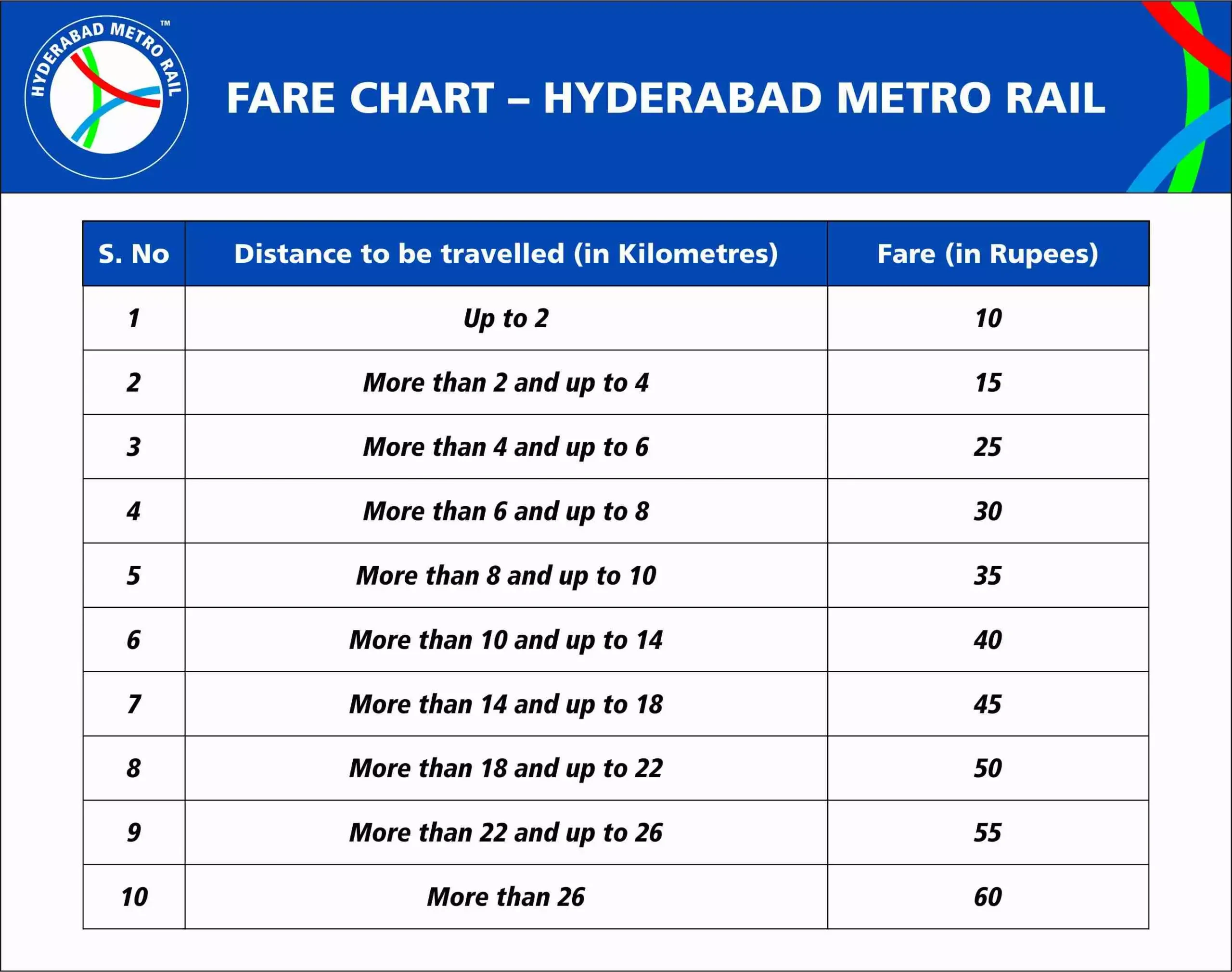
- Fare Range: Expected between ₹10 and ₹50 depending on distance.
With smart technology, ticketing on the Silver Line Metro will be fast and user-friendly.
Importance of Silver Line Metro
- Reduces Traffic Jams – Offers a faster alternative to road transport.
- Supports Eco-Friendly Travel – Decreases pollution levels.
- Boosts Economy – Improves connectivity to offices, markets, and airports.
- Saves Time – Provides a reliable, on-time journey.
- Tourist-Friendly – Connects important landmarks and travel hubs.
Silver Line Metro and Tourism
The metro will also help tourists explore the city with ease. Landmarks like monuments, cultural centers, and shopping hubs will be directly accessible through the Silver Line Metro Map. This reduces dependence on taxis and autos.
Latest Updates on Silver Line Metro (2025)
- Construction work is in full swing.
- Advanced tunneling technology is being used for underground stretches.
- Trial runs are expected soon on some sections.
- The complete route may be operational in phases by the next few years.
Passengers are advised to check the official metro website for the latest Silver Line Metro Map PDF.
Future of Silver Line Metro
Once operational, the Silver Line Metro will:
- Become a backbone of daily urban travel
- Reduce road congestion significantly
- Encourage more people to shift from cars to public transport
- Inspire more metro projects in other cities
Tips for Passengers
- Download the official metro app for live updates.
- Use smart cards to save money and time.
- Plan travel during non-peak hours if possible.
- Check the Silver Line Metro Map before boarding.
- Follow safety rules while traveling.
Conclusion
The Silver Line Metro Map is more than just a transport guide – it represents the future of sustainable and modern travel in India. With advanced technology, eco-friendly infrastructure, and better connectivity, the Silver Line is expected to transform the daily lives of millions of people.
Whether you are a regular commuter, a tourist, or a student, the Silver Line Metro will soon become your fastest, cheapest, and most reliable travel partner.
Stay updated with the latest developments and download the Silver Line Metro Map PDF for easy navigation.