In the bustling heart of Hyderabad—often dubbed the City of Pearls—the Hyderabad Metro map Rail is not merely a transport system; it’s a dynamic lifeline that bolsters economic growth, reduces congestion, and embraces modern innovations. Launched in 2017, this rapid transit network has swiftly become a symbol of progress, connecting residents and visitors to key destinations across the metropolitan region .
From Vision to Reality: A Brief History & Overview
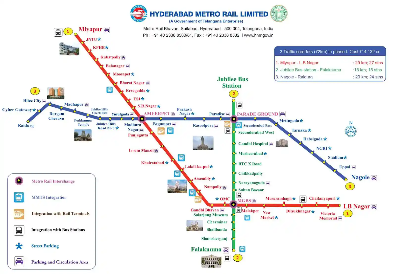
The Hyderabad Metro Rail project was conceived to address the escalating challenges of urban mobility in one of India’s fastest-growing cities. Inaugurated on November 29, 2017, the project was developed under a public–private partnership model—with Larsen & Toubro holding a 90% stake and the Government of Telangana a 10% share. Remarkably, it is the world’s largest elevated metro rail system implemented on a DBFOT (Design, Build, Finance, Operate, and Transfer) basis, transforming the commuting experience for millions .
Navigating the Network: Routes & Distinctive Features
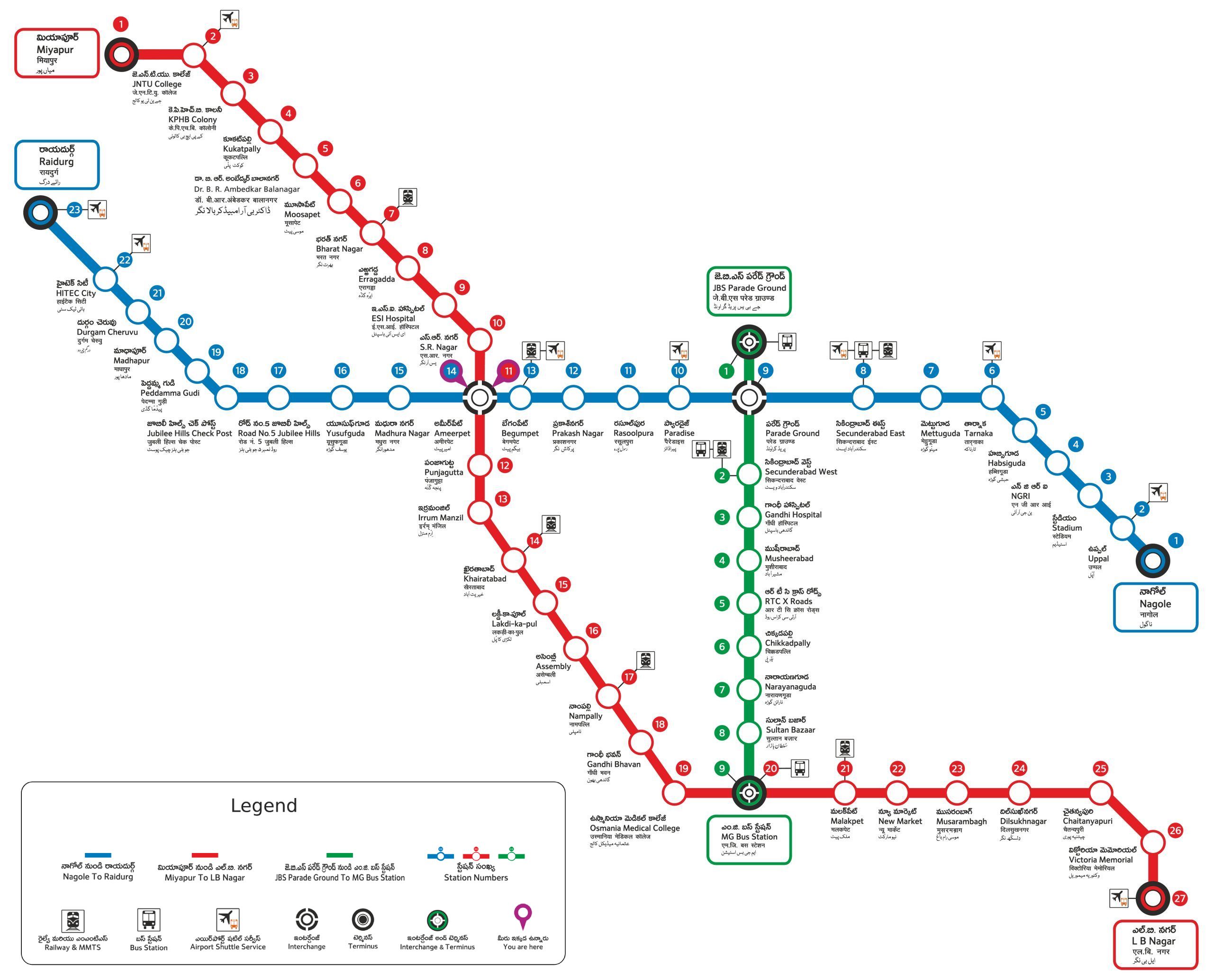
The Hyderabad Metro network currently features three fully operational lines—each color-coded for ease of navigation.
- Red Line: This line connects key hubs like Miyapur, JNTU College, Raidurg, and Hitech City, making it essential for the city’s IT professionals and students.
- Green Line & Blue Line: These lines branch out to cover crucial commercial and residential districts, ensuring seamless connectivity across Hyderabad.
Spanning approximately 69 kilometers of operational track and serving a daily ridership of over 500,000 commuters, the metro system has been instrumental in reducing travel time and mitigating urban congestion .
Innovation & Smart Transit Solutions
At its core, the Hyderabad Metro is a testament to innovation. Modern features include:
- Smart Ticketing: With contactless transactions and mobile app integrations (like TSavaari), embarking on your daily journey is both swift and secure.
- Sustainable Design: Emphasizing eco-friendly practices, the metro rail significantly cuts down carbon emissions, complementing Hyderabad’s evolving green initiatives.
- State-of-the-Art Safety Systems: Robust security measures such as CCTV surveillance and dedicated emergency protocols ensure a safe travel experience for all passengers.
Empowering the Commuter:
To truly enjoy the Hyderabad Metro experience, consider these commuter tips:
- Peak vs. Off-Peak Hours: For a more relaxed journey, opt for off-peak travel times.
- Mobile Connectivity: Leverage the official metro app for real-time updates on train schedules and service alerts.
- Station Amenities: Many stations double as hubs for local art, eateries, and retail outlets—offering a slice of local flavor during your commute.
Looking Ahead: The Future of Hyderabad Metro Map
As Hyderabad continues to grow, so does its metro network. With additional lines under planning and construction, future phases promise to extend connectivity, ease last-mile challenges, and further integrate the metro into the fabric of city life. This evolution not only underscores the commitment to sustainable urban transit but also positions the Hyderabad Metro as a critical asset in the city’s long-term developmental strategy.
Hyderabad Metro Map FAQ
What are the operating hours of the Hyderabad Metro?
Typically, the Hyderabad Metro runs from around 5:30 AM to 11:00 PM. However, timings may vary on specific lines or days, so it’s advisable to consult the official app or website for the most current schedule
How does the fare system work?
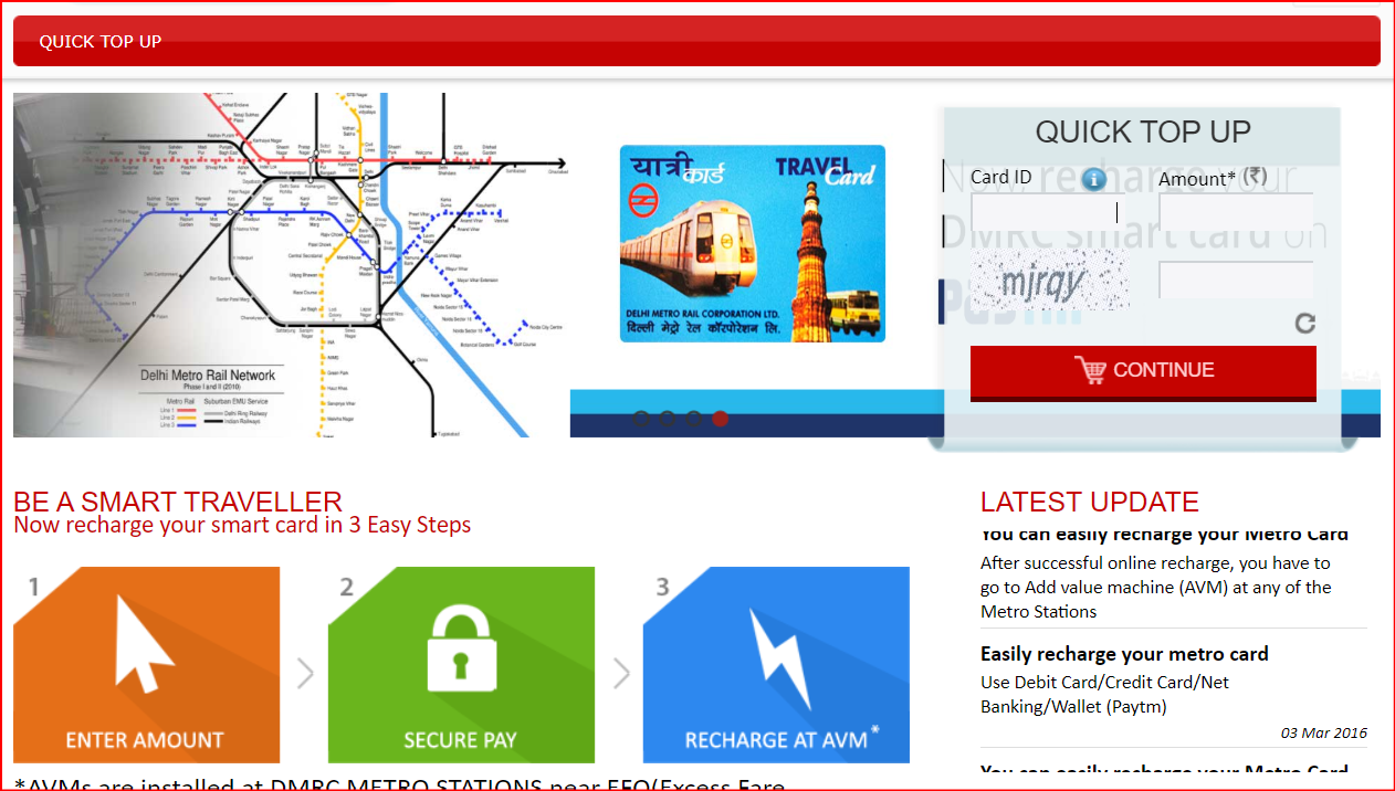
Fares on the Hyderabad Metro are designed to be commuter-friendly—varying based on journey distance. Passengers can choose between purchasing single-journey tokens or using a rechargeable Smart Card that often offers discounted rates.
How many lines and stations are currently operational?
The current network comprises three fully operational lines (Red, Green, and Blue) with a total of 57 stations. This provides a robust and far-reaching network across Hyderabad .
Which areas does the Red Line serve?
The Red Line is one of the most critical corridors, connecting areas such as Miyapur, JNTU College, Raidurg, and Hitech City. This makes it particularly popular among professionals and students working in the IT hub.
What sets Hyderabad Metro apart from other metro systems?
A few distinguishing features include its status as the world’s largest elevated metro rail system on a DBFOT basis, its cutting-edge smart ticketing solutions, environmentally sustainable design, and an ever-expanding network built to accommodate rapid urban growth .
Conclusion
The Hyderabad Metro is more than a means of transportation—it’s a cornerstone of modern urban lifestyle in Hyderabad. Whether you’re a daily commuter or a curious traveler, embracing the metro means experiencing faster transit, enhanced convenience, and a commitment to a greener future. As the network grows, so does its potential to redefine how we move within the city.
Ready to embark on your next metro journey, or interested in the latest updates on route expansions? Dive deeper into the world of urban mobility and share which station or feature you find most fascinating!
- About Us
- Chennai Metro Map – Route Guide, Interchanges & Expansion Updates
- Contact Us
- Delhi Metro Map 2025 – Routes, Lines, Stations & Interchange Guide download pdf
- Delhi Metro Map, Routes & Fare Calculator | Complete Guide for 2025
- Disclaimer
- Hyderabad Metro Map – Complete Guide to Routes, Timings, Fares, and Stations
- Hyderabad Metro Network Map View and Download pdf of Map
- Metro Map: View metro rail Map and Download PDF for Travel Guide
- Mumbai Metro Map (2025) – Complete Route Guide, Lines & Interchanges
- Plan Your Trip Hyderabad Metro
- Privacy Policy