The Hyderabad Metro Map is one of India’s most modern and fastest-growing urban transport systems. It has transformed daily commuting across the twin cities of Hyderabad and Secunderabad, offering a safe, fast, and eco-friendly way to travel. Whether you are a resident, a student, or a tourist, understanding the Hyderabad Metro Map can make your travel smoother and more convenient.
In this article, we’ll explore everything about the Hyderabad Metro — including its routes, stations, fare chart, timings, ticket options, mobile app, and future expansion plans. By the end, you’ll have a complete guide that helps you plan your journey with confidence.
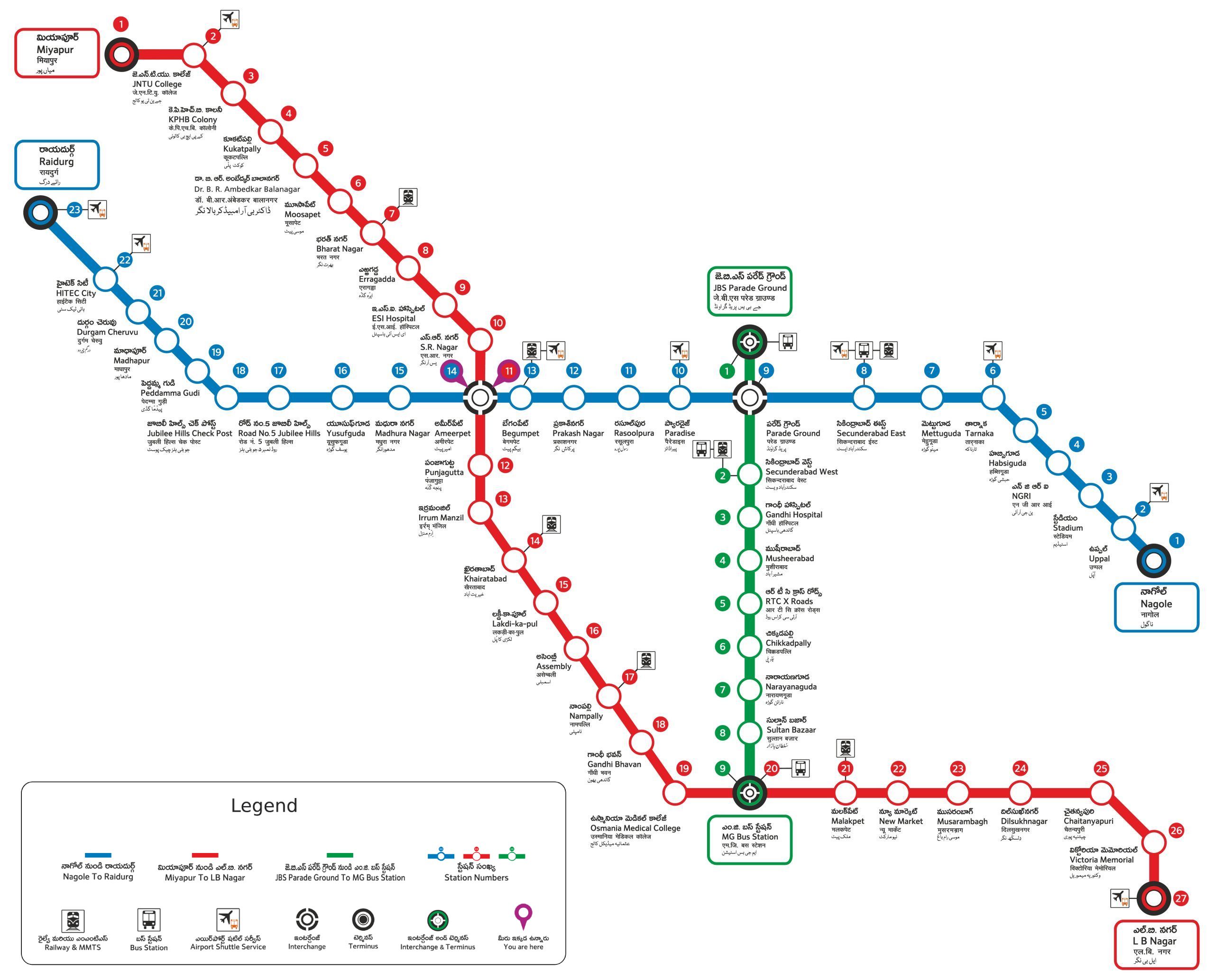
Hyderabad-Metro-MapWhat Is Hyderabad Metro Rail?
The Hyderabad Metro Rail (HMRL) is a rapid transit system serving Hyderabad, Telangana. It was inaugurated on 29 November 2017 by Prime Minister Narendra Modi. The project was developed under a Public-Private Partnership (PPP) model with L&T Metro Rail (Hyderabad) Limited as the concessionaire.
With a total route length of 69.2 kilometers and 57 stations, it’s the second longest operational metro network in India, after Delhi Metro. The system connects important residential, business, and cultural areas of the city.
Overview of Hyderabad Metro Map
Below is a quick summary of the Hyderabad Metro Rail system:
Overview Table
| Feature | Details |
|---|---|
| Project Name | Hyderabad Metro Rail |
| Total Operational Length | 69.2 km |
| Number of Stations | 57 |
| Number of Corridors | 3 |
| Operator | L&T Metro Rail (Hyderabad) Limited |
| Inauguration Date | 29 November 2017 |
| Average Speed | 33 km/h |
| Maximum Speed | 80 km/h |
| Type | Elevated Rapid Transit System |
| Ticketing Options | Smart Card, Paper Ticket, QR Code |
| Website | www.ltmetro.com |
Hyderabad Metro Map – Full Route Details
The Hyderabad Metro consists of three main corridors identified by color codes — Red Line, Blue Line, and Green Line.
1. Red Line (Miyapur – LB Nagar)
The Red Line is the busiest and most popular corridor. It connects major commercial and residential areas in the north and south of Hyderabad.
Route Details:
- Length: 29.2 km
- Stations: 27
- Key Stations: Miyapur, Kukatpally, Ameerpet, Dilsukhnagar, LB Nagar
- Interchange Station: Ameerpet (connects to Blue Line)
This corridor is ideal for commuters traveling from IT hubs to residential localities.
2. Blue Line (Nagole – Raidurg)
The Blue Line connects the eastern part of the city to the western IT corridor. It’s highly used by tech employees traveling to HITEC City and Raidurg.
Route Details:
- Length: 27 km
- Stations: 23
- Key Stations: Nagole, Tarnaka, Parade Grounds, Ameerpet, HITEC City, Raidurg
- Interchange Station: Ameerpet (connects to Red Line)
This line plays a crucial role in linking the tech and commercial zones of Hyderabad.
3. Green Line (JBS Parade Ground – MG Bus Station)
The Green Line runs from JBS Parade Ground (Secunderabad) to Mahatma Gandhi Bus Station (MGBS) and primarily serves central Hyderabad.
Route Details:
- Length: 11 km
- Stations: 9
- Key Stations: JBS Parade Ground, Secunderabad West, Gandhi Hospital, MGBS
- Interchange Station: MGBS (connects to Red Line)
This corridor connects two major bus terminals — JBS and MGBS — making it vital for intercity travelers.
Interchange Stations
There are two interchange stations where passengers can switch between metro lines:
- Ameerpet Station – Between Red and Blue Lines
- Mahatma Gandhi Bus Station (MGBS) – Between Red and Green Lines
These interchanges allow passengers to travel across Hyderabad efficiently without long detours.
Hyderabad Metro Map (Visual Layout)
Although we can’t show the live image here, the official Hyderabad Metro Map shows all three lines branching out like a triangle:
- Red Line (Miyapur–LB Nagar) – North to South
- Blue Line (Nagole–Raidurg) – East to West
- Green Line (JBS–MGBS) – Central Connector
You can download or view the full metro map on the L&T Metro official website or Google Maps for real-time navigation.
Metro Timings
The Hyderabad Metro operates daily with convenient timings for office goers, students, and travelers.
| Day | First Train | Last Train |
|---|---|---|
| Monday to Saturday | 6:30 AM | 11:00 PM |
| Sunday | 7:00 AM | 11:00 PM |
Train frequency varies:
- Peak hours: Every 3–5 minutes
- Non-peak hours: Every 7–10 minutes
Hyderabad Metro Fare Chart
Fares are based on the distance traveled. The minimum fare starts from ₹10 and goes up to ₹60 for the longest journey.
Example Fare Table:
| Distance Range | Fare (INR) |
|---|---|
| 0–2 km | ₹10 |
| 2–4 km | ₹15 |
| 4–6 km | ₹25 |
| 6–10 km | ₹30 |
| 10–16 km | ₹40 |
| 16–24 km | ₹50 |
| 24+ km | ₹60 |
You can pay using Smart Card, Paper Ticket, or QR Code Ticket through the TSavaari mobile app.
Ticket Options
- Smart Card:
- Rechargeable metro card for daily commuters.
- Can be recharged online or at metro stations.
- Offers 10% discount on fares.
- Paper Ticket:
- Available for one-time travel.
- Valid only on the day of issue.
- QR Code Ticket:
- Buy and scan tickets using the TSavaari app.
- Completely contactless and fast.
TSavaari App
The TSavaari Mobile App is the official Hyderabad Metro app that helps passengers plan their journey easily.
Features:
- Route planner
- Live train timings
- Fare calculator
- Station information
- QR ticket booking
- Smart card recharge
Available on both Android and iOS platforms.
Facilities at Metro Stations
The Hyderabad Metro is known for its modern and user-friendly design. Stations are equipped with:
- Escalators and elevators
- Clean restrooms
- CCTV surveillance
- Parking facilities
- Retail shops and ATMs
- Accessibility for differently-abled passengers
Hyderabad Metro Feeder Services
To make last-mile connectivity smoother, Hyderabad Metro offers feeder bus services from major metro stations to nearby residential and business hubs. Auto-rickshaws and bike taxis also operate outside key metro stations.
Tourist Attractions Near Metro Stations
The metro connects several major attractions in Hyderabad:
| Attraction | Nearest Metro Station | Line |
|---|---|---|
| Charminar | MGBS | Green Line |
| Hussain Sagar Lake | Rasoolpura | Blue Line |
| Birla Mandir | Lakdi-ka-Pul | Red Line |
| HITEC City | HITEC City | Blue Line |
| NTR Gardens | Khairatabad | Red Line |
| Salar Jung Museum | MGBS | Green Line |
So if you’re planning a day out in Hyderabad, the metro is the easiest way to reach popular spots quickly.
Benefits of Hyderabad Metro
The Hyderabad Metro is not just about convenience — it’s about a greener and smarter city. Here are its major benefits:
- Reduced Traffic Congestion: Helps decongest busy roads like Ameerpet, Kukatpally, and Dilsukhnagar.
- Eco-Friendly Travel: Powered by electricity, reducing carbon emissions.
- Time-Saving: Bypasses road jams and traffic signals.
- Affordable: Competitive fares compared to cabs or autos.
- Safety: CCTV, security guards, and emergency systems at every station.
- Economic Boost: Improves accessibility to commercial zones and increases real estate value around metro corridors.
Future Expansion Plans
The Hyderabad Metro is expanding further to reach new parts of the city. Upcoming projects include:
- Airport Metro Line (Blue Line Extension):
- From Raidurg to Rajiv Gandhi International Airport (Shamshabad)
- 31 km new line, targeted completion by 2027.
- Old City Line Extension:
- Red Line extension from MGBS to Falaknuma
- 5.5 km with new stations planned.
These extensions will make the Hyderabad Metro one of the most comprehensive urban transport systems in South India.
Safety Measures
The Hyderabad Metro follows strict safety protocols:
- Regular disinfection of trains and stations
- Fire detection systems
- Emergency buttons inside coaches
- Women-only coaches for safer travel
- Continuous monitoring by central command center
Tips for First-Time Metro Users
If you’re new to Hyderabad Metro, keep these tips in mind:
- Always stand on the left side of the escalator for others to pass.
- Keep your ticket or card ready at entry and exit gates.
- Avoid eating or drinking inside the train.
- Follow announcements for interchange and next station updates.
- Use the TSavaari app for live train timings.
Conclusion
The Hyderabad Metro Map is not just a set of routes — it represents the new face of Hyderabad’s progress. With well-planned connectivity, modern facilities, and eco-friendly design, the metro has truly revolutionized the city’s transport system.
Whether you are commuting daily for work, visiting tourist places, or exploring the city as a student, the Hyderabad Metro offers you a smart, safe, and time-saving way to travel. So the next time you step out, plan your route using the Hyderabad Metro Map and experience the comfort of modern urban travel.