In the heart of every modern city, transportation forms the backbone of progress and convenience. Among the various modes of public transport, metro rail systems have emerged as one of the most efficient, eco-friendly, and time-saving options for millions of daily commuters. Whether you are a resident traveling to work or a tourist exploring a city, one essential tool makes metro travel easy — the Metro Map.
This article provides a complete guide to understanding metro maps, their importance, how to read them, and the details of popular metro systems across India, such as Delhi, Mumbai, Bengaluru, Hyderabad, and Kolkata.
Hyderabad Metro Rail Pdf
Delhi Metro Map PDF
What is a Metro Map?
A metro map is a schematic representation of a city’s metro rail network. It shows all the metro lines, stations, and interchange points in a simplified, easy-to-read design. Unlike geographic maps, metro maps don’t focus on the actual distances between stations but instead prioritize clarity and navigation.
Each line is represented by a unique color (like Blue Line, Yellow Line, or Green Line) so passengers can easily identify routes and connections. Station names are marked clearly, and interchange stations—where two or more lines meet—are highlighted with special symbols.
Metro maps are displayed at stations, inside trains, and available digitally on official websites and apps, helping passengers plan their journeys efficiently.
Why Metro Maps Are Important
Metro maps may look simple, but they are a powerful tool for smooth travel in busy urban environments. Here’s why metro maps play such a crucial role:
- Simplify Navigation:
Metro maps show all lines and interconnections clearly, helping passengers quickly plan the shortest and most convenient routes. - Save Time and Effort:
With a metro map, you can avoid confusion, missed stops, or wrong directions — saving both time and mental effort. - Ideal for Tourists and Newcomers:
Visitors unfamiliar with city geography can easily navigate using metro maps without asking for directions. - Support Urban Planning:
Metro maps reflect city development and expansion, showing new routes and future metro lines. - Promote Public Transport Usage:
Easy-to-read metro maps encourage people to use metro systems instead of private vehicles, reducing traffic congestion and pollution.
Key Features of a Metro Map
A good metro map is designed to be simple, intuitive, and visually organized. Some of the key features include:
1. Color-Coded Lines
Each metro line is shown in a different color — for example:
- Blue Line
- Yellow Line
- Green Line
- Violet Line
- Magenta Line
This helps commuters easily identify and follow their specific route.
2. Station Names
All station names are written clearly in both English and regional languages (such as Hindi, Kannada, or Bengali). Major interchange stations are highlighted or circled.
3. Interchange Stations
These are points where two or more metro lines intersect. For instance, Rajiv Chowk in Delhi is an interchange between the Yellow and Blue Lines.
4. Terminal Points
The first and last stations on a metro line are marked as terminal stations, such as Dwarka Sector 21 or Noida Electronic City on the Delhi Metro Blue Line.
5. Landmarks and Zones
Some advanced metro maps also display nearby landmarks, tourist attractions, or fare zones to help commuters plan better.
How to Read a Metro Map (Step-by-Step Guide)
If you’re new to metro travel, reading a metro map may seem confusing initially. Follow these simple steps:
- Find Your Starting Station:
Locate the station where you are currently. - Locate Your Destination Station:
Identify the station where you want to go. - Trace the Line:
Check if both stations are on the same colored line. If yes, follow that line directly. - Find Interchange Stations (if required):
If your source and destination are on different lines, find the interchange station where you can switch lines. - Count the Stops:
Counting stops between your start and destination helps you track progress and know when to get off. - Estimate Time and Fare:
Most metro apps and boards show approximate travel times and fare charts.
Example:
If you are traveling from Kashmere Gate to Botanical Garden in Delhi Metro:
- Start from the Red Line at Kashmere Gate.
- Interchange at Rajiv Chowk to the Blue Line.
- Continue till Botanical Garden.
Advantages of Using Metro Maps
Metro maps provide more than just directions. Here are the benefits they offer to daily commuters and city travelers:
- 🕒 Time Management: Plan your route in advance to avoid last-minute confusion.
- 💸 Cost Saving: Choose the shortest or least expensive route.
- 🌍 Eco-Friendly Choice: Encourages metro use, reducing fuel usage and emissions.
- 💡 Travel Confidence: Reduces anxiety for first-time metro users.
- 🚉 Accessibility: Helpful for differently-abled passengers to identify elevator-equipped stations.
Metro Maps in Major Indian Cities
India’s metro networks have expanded rapidly over the past two decades. Below is a detailed look at some of the most popular Indian Metro Maps and their unique features:
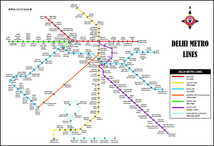
1. Delhi Metro Map
Delhi Metro is the largest and most advanced metro network in India. Managed by the Delhi Metro Rail Corporation (DMRC), it covers Delhi and extends to Noida, Ghaziabad, Faridabad, and Gurugram.
- Total Lines: 10+
- Major Lines: Red, Yellow, Blue, Violet, Green, Magenta, Pink, Grey, Orange (Airport Express)
- Total Stations: Over 290
- Notable Interchanges: Rajiv Chowk, Kashmere Gate, Hauz Khas, Central Secretariat
Delhi Metro Map Features:
- Bilingual (Hindi & English)
- Color-coded and easy to follow
- Displays interconnections to Rapid Metro and Airport Express
Example Route:
If traveling from Dwarka Sector 21 to Noida Sector 62, follow the Blue Line directly — one of the longest single-line routes.
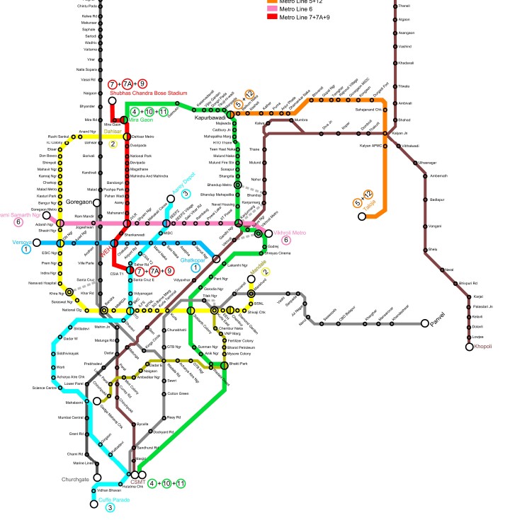
2. Mumbai Metro Map
Mumbai’s metro system complements the city’s famous suburban train network. Operated by Mumbai Metro One Pvt Ltd and MMRDA, it aims to decongest road traffic.
- Total Lines (Operational + Under Construction): 14 planned lines
- Major Lines: Line 1 (Versova–Ghatkopar), Line 2A, Line 7, Line 3 (under construction)
- Total Stations: 50+ (and expanding)
Key Features:
- Integrates with local train and monorail
- Smart card and mobile ticketing available
- Color-coded design similar to global metro maps
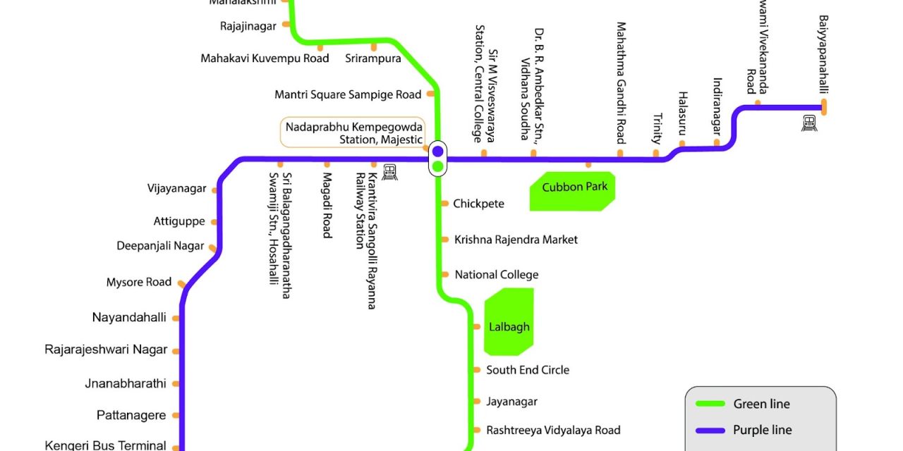
3. Bengaluru Metro Map (Namma Metro)
Bengaluru’s Namma Metro is managed by the Bangalore Metro Rail Corporation Limited (BMRCL). It connects major business hubs and residential areas.
- Total Lines: 2 (Green & Purple)
- Total Stations: 60+
- Network Length: Over 70 km
Highlights:
- The Purple Line runs east-west, and the Green Line runs north-south.
- Interchange station: Majestic (Kempegowda)
- Fully integrated smart card ticketing system
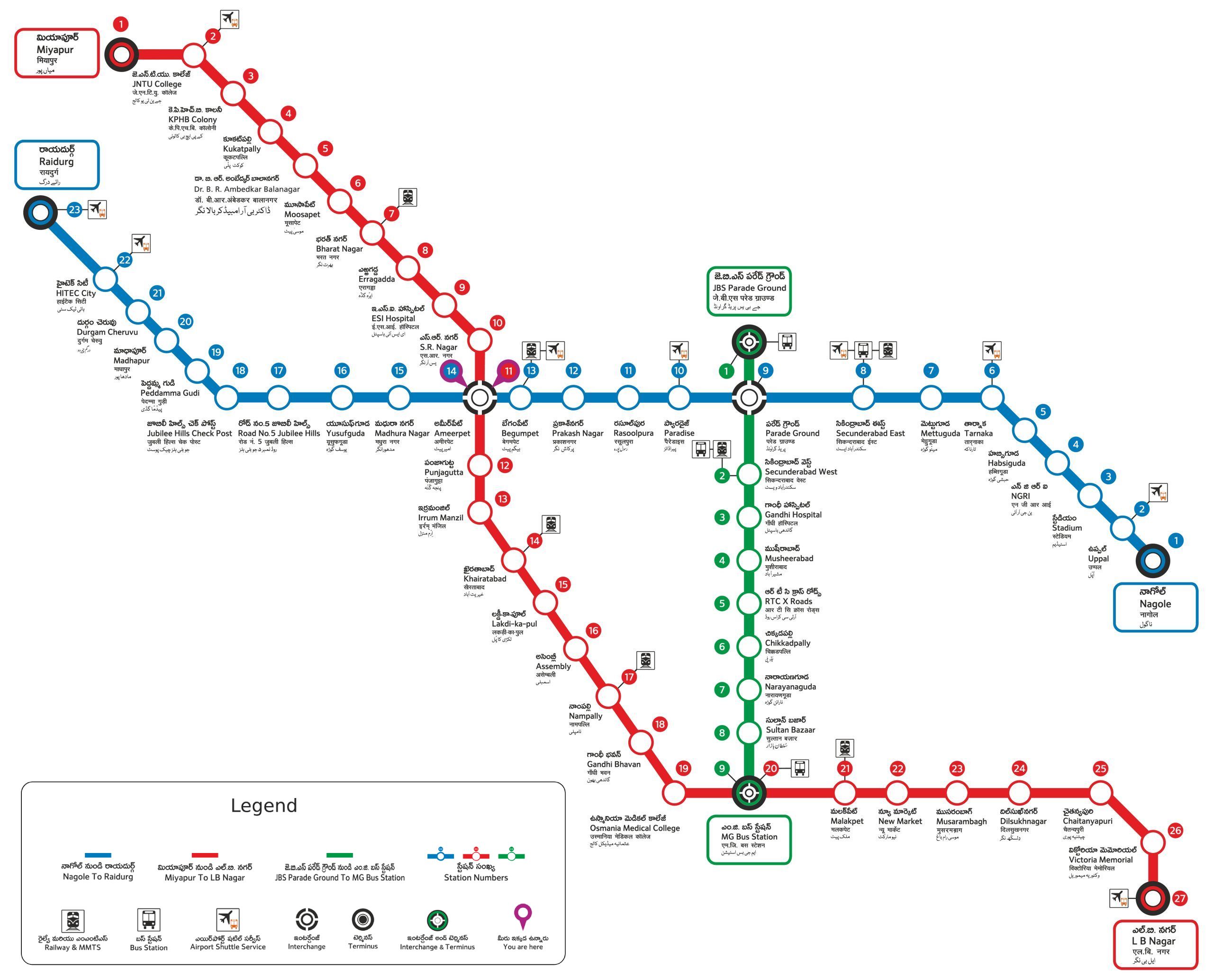
4. Hyderabad Metro Map
Hyderabad Metro, managed by L&T Metro Rail Hyderabad Ltd, is one of the most modern systems in India.
- Total Lines: 3 (Red, Blue, Green)
- Total Stations: Around 55
- Key Interchange: Ameerpet
Highlights:
- Smart card and mobile QR code ticketing
- Real-time train tracking via app
- Wide coverage across the city, including IT hubs like Hitech City

Metro Ticket Price in India Here is Chart of Metro Trian ticket Price
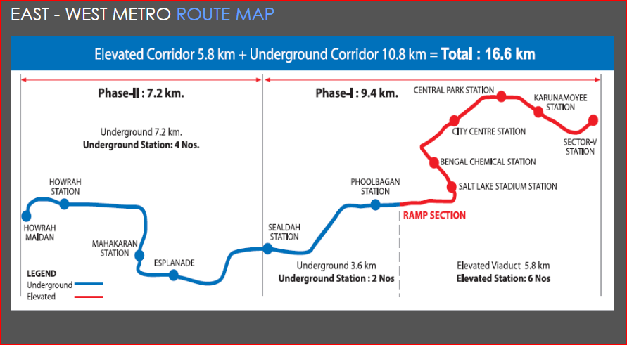
5. Kolkata Metro Map
The Kolkata Metro is India’s oldest metro system, launched in 1984. Managed by Indian Railways, it continues to expand with multiple corridors.
- Total Lines (Operational + Upcoming): 4+
- Major Lines: North–South (Blue Line), East–West (Green Line)
- Total Stations: 40+
- Key Interchange: Esplanade
Special Feature:
Kolkata Metro retains its traditional map design while incorporating modern digital updates.
Digital Metro Maps and Mobile Integration
With technological advancements, metro maps are no longer limited to printed posters. Digital metro maps are now available through official websites, apps, and Google Maps.
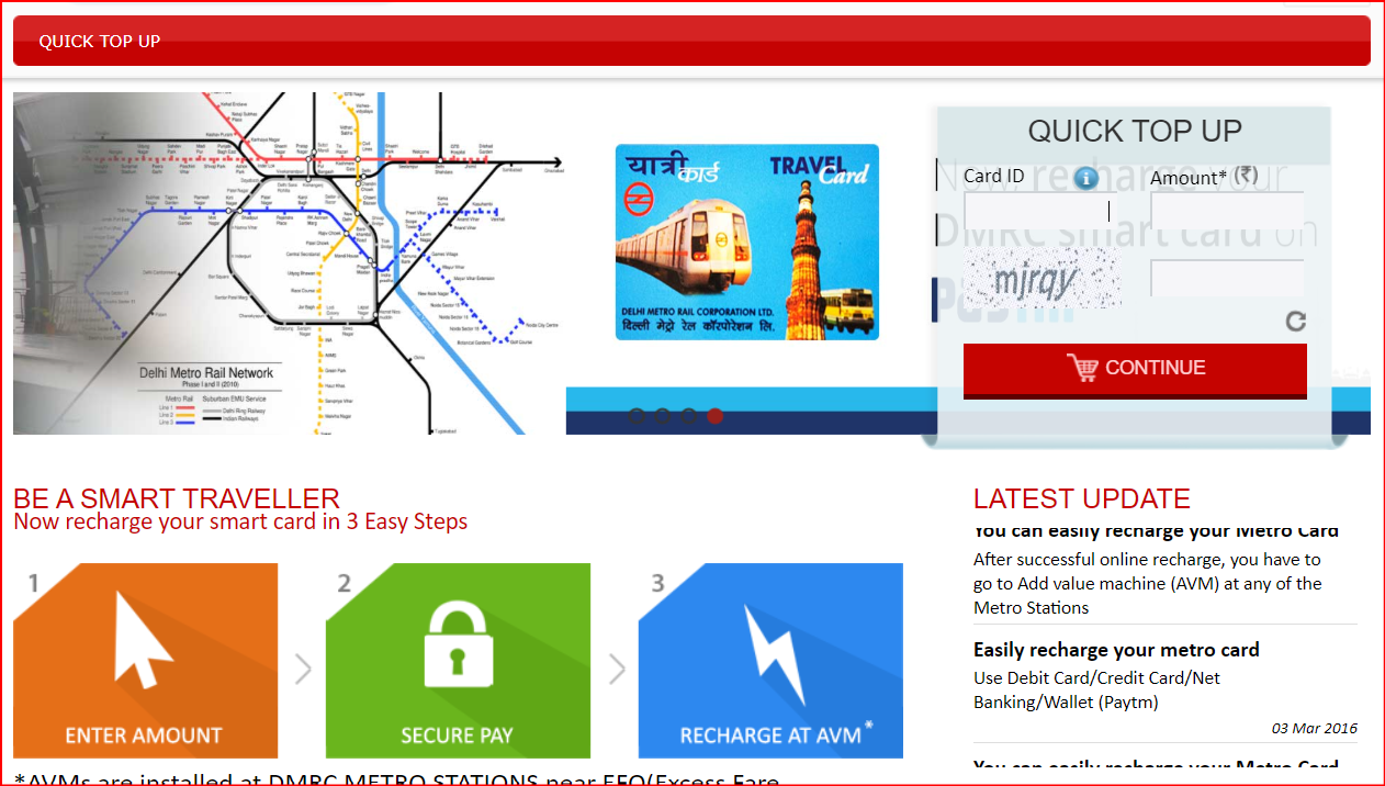
How to Recharge Metro Card Online – Complete Step by Step Guide
Benefits of Digital Metro Maps:
- Interactive Navigation: Zoom, click, and trace routes easily.
- Real-Time Updates: Get live information on station closures or maintenance.
- Fare Calculator: Check ticket prices instantly.
- Accessibility Options: Find elevators, escalators, and parking spots.
- Route Suggestions: Suggests the fastest route with fewer interchanges.
Popular Apps:
- Delhi Metro Rail App (DMRC)
- Namma Metro App
- Hyderabad Metro App
- Google Maps (Transit Mode)
How Metro Maps Help Urban Development
Beyond guiding passengers, metro maps contribute to urban growth and planning. Here’s how:
- Real Estate Development: Properties near metro stations often see higher demand.
- Reduced Traffic Congestion: Fewer cars mean less pollution and smoother traffic.
- Boosts Economy: Improves connectivity to business hubs.
- Social Inclusion: Enhances accessibility for all citizens.
- Sustainability: Encourages environmentally friendly travel.
Future of Metro Maps in India
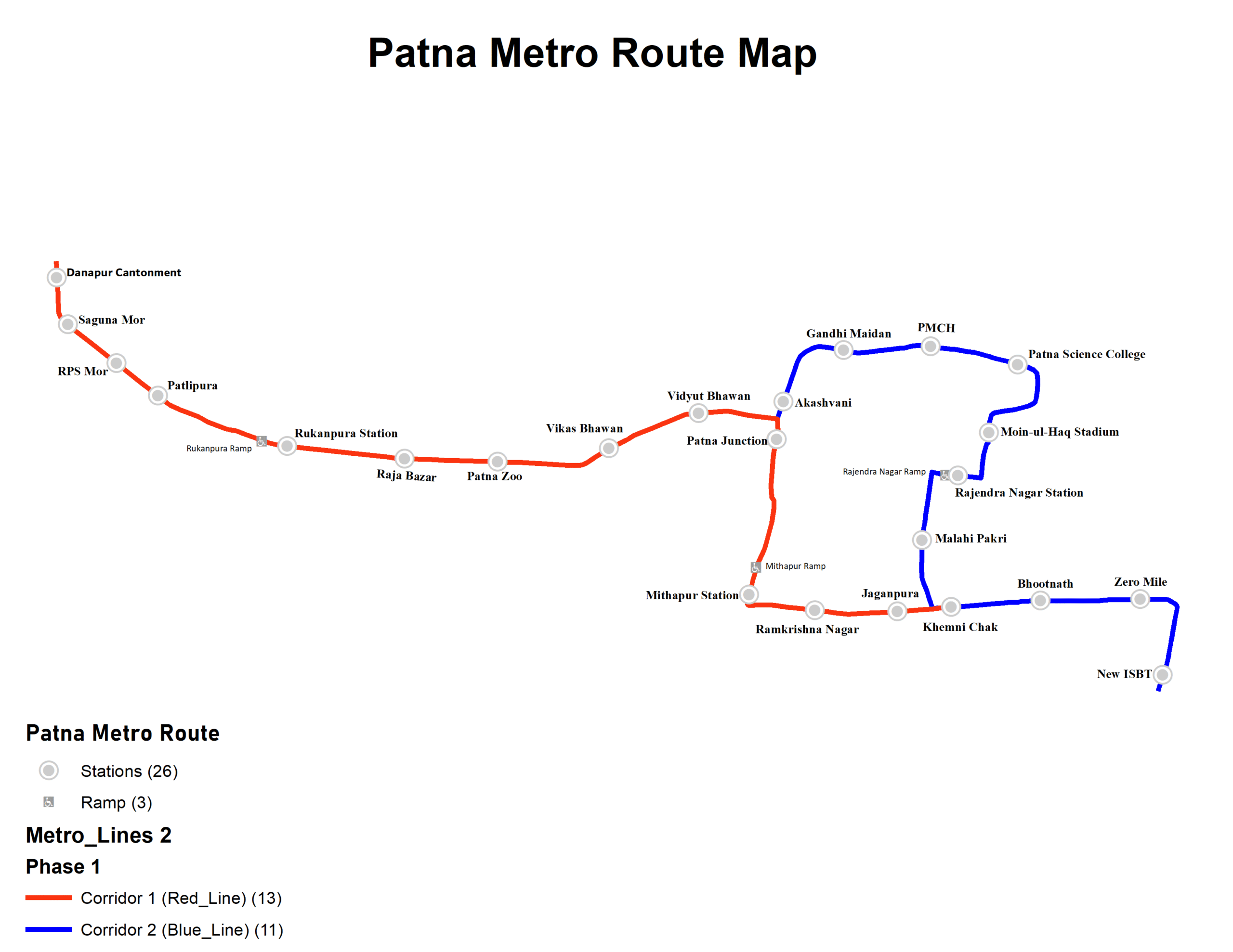
India’s metro systems are expanding rapidly. Cities like Pune, Ahmedabad, Nagpur, Kanpur, Jaipur, Patna, Lucknow, and Bhopal already have operational or under-construction metro lines.
Upcoming Innovations:
- 3D Digital Metro Maps
- Augmented Reality (AR) Navigation
- AI-Powered Route Planning
- Integration with other transport modes (bus, rail, e-rickshaw)
Soon, passengers will be able to plan end-to-end journeys using a single integrated smart map.
DMRC Donlaod Metro Route Map and Check Faire, Recharge you Card Complete Guide 2025
Tips for Using Metro Maps Efficiently
- Always keep a digital or printed metro map handy.
- Check for updates as metro routes often expand.
- Learn major interchange stations to simplify your route.
- During rush hours, choose alternate lines if available.
- Use official apps for live train status and fare details.
Conclusion
A Metro Map is much more than just a diagram — it’s a symbol of modern urban mobility and smart planning. It simplifies travel, saves time, and promotes a cleaner, greener mode of transportation. Whether you are in Delhi, Mumbai, Bengaluru, or any other metro city, understanding the metro map helps you travel confidently and efficiently.
As India’s metro networks continue to grow, the Metro Map will remain the ultimate travel companion — guiding millions toward faster, safer, and smarter journeys every single day.
Also, Check this-
- Silver line metro map Changed to Gold colour Complete Guide
- Kolkata Metro Map View Rouite and travel Complete Guide
- Metro Cities in India Complete Guide and Detailed Blog
- What is a Metro City? The term “Metro City” is short for Metropolitan City.
- DMRC Metro Map Download Pdf of Delhi Metro Map and View Metro Map